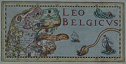
Leo Belgicus
The Seventeen Provinces of the Low Countries depicted in the form of a lion was first introduced by the Austrian nobleman Baron Michael Aitzinger. Baron Aitzinger had studied at the Universities of Vienna and Louvain before undertaking an extensive tour of Europe that lasted around thirty years. He finally settled in Cologne where his history of the Low Countries, published in 1583, contained a map that utilised the shape of the coastline combined with the fact that most of the provinces used a lion in their coat of arms. This image of 'Leo Belgicus' proved very popular, even if after Aitzinger had published his prototype, the political situation had altered considerably. The Provinces had risen in revolt against the Spanish, who succeeded in subduing the southern provinces, but not the seven northern provinces. The Revolt was suspended during the Twelve Years Peace (1609-1621), before resuming, and continuing to 1648, when the Dutch Republic established its independence. There are four main variants as follows:
1. The Lion standing on its hind legs, facing east (to the right of the page), the earliest form.
2. The Lion standing, facing southward, first appearing circa 1611.
3. The Lion seated, in peaceful mood, produced at the time of the Twelve Years Truce (1609-1621).
4. The 'Leo Hollandicus', produced and published as it became increasingly clear that the Seven United Provinces would win its independence.
This curious form of cartography continued for over two centuries, being redrawn and redesigned by many artists and remains today as one of the highpoints in 'Golden Age' mapmaking.
|
 Leo Belgicus, published by Pieter Van der Keere in Amsterdam in 1617, 450mm x 365mm Leo Belgicus, published by Pieter Van der Keere in Amsterdam in 1617, 450mm x 365mm
Van den Keere was a highly skilled and prolific Dutch engraver, who worked in both London and Amsterdam. In 1584 he came to England with his sister, Colette, who was to marry Jodocus Hondius, another Protestant refugee. Keere and Hondius perfected their engraving technique and returned to settle in Amsterdam in 1593.
Ref No: BELUX 744
|
 De Bello Belgico, published by Famiani Strada in Rome in 1632, 220mm x 312mm De Bello Belgico, published by Famiani Strada in Rome in 1632, 220mm x 312mm
Strada was a Jesuit teacher who was politically sympathetic to the Spaniards and wrote an extensive historical piece, discussing the Dutch wars of independence. This early map shows the Belgian Lion seated, right forepaw raised, resting on a shield.
Ref No: BELUX 665
|
 Sol in Leone Belgico, published by Philippe Galle in Antwerp in 1640, 138mm x 105mm Sol in Leone Belgico, published by Philippe Galle in Antwerp in 1640, 138mm x 105mm
Philippe Galle was an editor, engraver and printseller from Haarlem but was active in Antwerp. He co-published the first part of Braun and Hogenberg's six volume series Civitates Orbis Terrarum and also engraved the portrait of Ortelius in Theatrum Orbis Terrarum. Galle also published a map of the Seventeen Provinces on 12 sheets. (no longer in stock)
|
 De Bello Belgico, published by Famiani Strada in Rome in 1651, 137mm x 180mm De Bello Belgico, published by Famiani Strada in Rome in 1651, 137mm x 180mm
Famiani Strada was a teacher at the Collegium Romanum in Rome and produced this map for the two volume edition on his work on the Dutch War of Independence.
Ref No: BELUX 667
|
The Map House of London
54 Beauchamp Place
Knightsbridge
London SW3 1NY
United Kingdom
Tel: +44 (0)20 7589 4325
Fax: +44 (0)20 7589 1041
E-mail: maps@themaphouse.com